


Ruins
The Turret
Through the years
How is might have looked
Ransom Gillis
Alfred Street Pictures and Maps
Henry T. Brush and Jeanie Flora Campbell
Structures of Henry T. Brush
Alanson J. Fox
Speaches of Alanson J. Fox
Pewabic Pottery
The Essa's
The Storefront
1943 Detroit Riot
Urban renewal?
Population Change in Detroit
Rise of Architecture in Detroit
Movie Cameos
le détroit (The Straits)
The Walls
Tiger Stadium, 100 Years On
Detroit Freeways
Who Makes It?
House Photos for Sale
More pics on
Alfred Street Pictures and Maps
"Alfred Street still exists. It runs at right angles to Woodward Avenue, less than a mile from
the center of Detroit, just as it always did. It is now in what city-planners call a blighted area.
The elms were long ago cut down. No representative of the old neighbor-families remains.
The houses, mostly standing as they stood a half-century ago, are dismal structures. Some
have night-blooming grocery stores in their front yards. Some have boarded windows. All
stand in bitter need of paint and repair.
It is a desolate street; a scene of poverty and chop-fallen gloom; possibly of worse things."
--From Alfred Street, by Russell McLauchlin, 1946
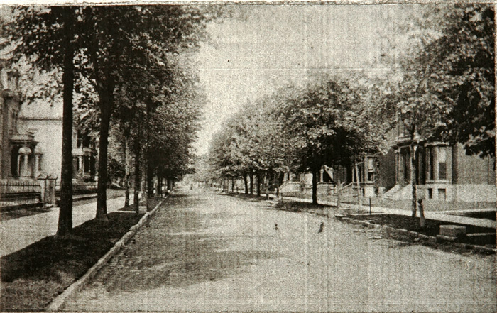
Looking up Alfred Street circa 1900, Burton Historical Collection, Detroit Public Library

Aerial View of Alfred Street 1897, Sanborn Maps, [http:// sanborn.umi.com.access-proxy.sno-isle.org/sanborn/image/download/pdf/mi/reel08/3985/00237/Detroit+1897 +vol.+3%2C+Sheet+14.pdf?CCSI=2578n] (8/30/2004)

Aerial View of Alfred Street 1920, Sanborn Maps, [http://sanborn.umi.com.access-proxy.sno-isle.org/sanborn/ image/download/pdf/mi/reel09/ 3985/00249/Detroit+1910-1950+vol.+3%2C+1921%2C+Sheet+16.pdf?CCSI=2578n] (8/30/2004)

Aerial View of Alfred Street 1940's, Sanborn Maps, [http://sanborn.umi.com.access-proxy.sno-isle.org/ sanborn/image/download/pdf/mi/reel13/3985/00255/Detroit+1910-July+1951+vol.+3%2C+1921- Nov.+1950%2C+Sheet+16.pdf?CCSI=2578n] (8/30/2004)
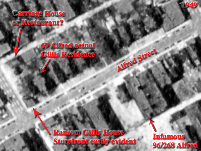
Aerial View of Alfred Street 1949. Storefront on corner of Ransom Gillis House easily evident. Building behind house looks like it may be the carriage house though that was supposed to be replaced by a restaurant in 1935. 69 Alfred, the Gillis' actual house for decades is still present. The infamous 96/268 Alfred that Woodward East tried to rehabilitate shown expanded to full apartment building. Conversion of 96/268 Alfred prior to 1921.
Photo: CULMA - Aerial Photo Collection, Wayne State University [http://www.clas.wayne.edu/photos/part2/wayne/1949/ha-3-145.pdf](10/2010)

Aerial View of Alfred Street 1952. Storefront still there. Building behind house looks like it is the same one that lasted till 2005. 69 Alfred and 96/268 Alfred still present.
Photo: CULMA - Aerial Photo Collection, Wayne State University [http://www.clas.wayne.edu/photos/part2/wayne/1952/de-29-25.pdf](10/2010)
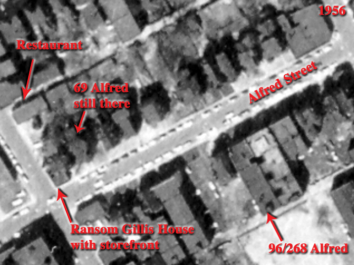
Aerial View of Alfred Street 1956. Storefront and neighboring structures still there.
Photo: CULMA - Aerial Photo Collection, Wayne State University [http://www.clas.wayne.edu/photos/part2/wayne/1952/de-29-25.pdf](10/2010)

Aerial View of Alfred Street 1961. Storefront and neighboring structures still there. The devastation of the area was still not evident from a few thousand feet in the air.
Photo: CULMA - Aerial Photo Collection, Wayne State University [http://www.clas.wayne.edu/photos/part2/wayne/1961/fm-30-127.pdf](10/2010)

Aerial View of Alfred Street 1981. Twenty years later even from a few thousand feet the devastation cannot be hidden. Storefront along with 69 Alfred and 96/268 Alfred have completely vanished. From this height the roof of the Ransom Gillis House still looks intact, it is quite a different story on the ground though.
Photo: CULMA - Aerial Photo Collection, Wayne State University [http://www.clas.wayne.edu/photos/part2/wayne/1981/17562-15-418.pdf](10/2010)

Aerial View of Alfred Street 1997. Sixteen years later even the sorrounding trees have been elliminated.
Photo: CULMA - Aerial Photo Collection, Wayne State University [http://www.clas.wayne.edu/photos/part2/wayne/1997/55739-25-57.pdf] (10/2010)

Aerial View of Alfred Street 2002. Roof of Ransom Gillis House visibly collapsed even when viewed from space.
USGS 2002 [http://terraserver-usa.com/image.aspx?T=4&S=9&Z=17&X=3309&Y=46899&W=1] (8/2004)
View Larger Map
Current aerial view.
Restaurant gone, house mothballed with new asphalt roof, Google Maps (http://maps.google.com/maps?gl=us&ie=UTF8&t=h&ll=42.344199,-83.052204&spn=0.001041,0.001875&z=19&source=embed)
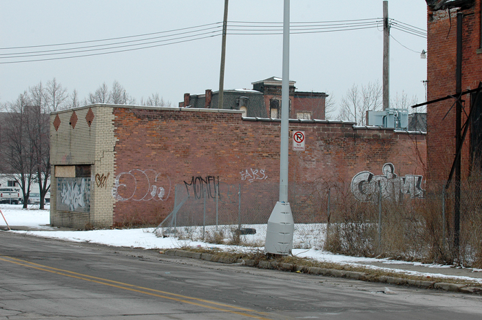
Resturant behind Ransom Gillis House, February 2005 (torn down 2006)
Photo: John Kossik
Any copyrighted material incorporated on this site is used in "fair use", for the purpose of study, review or critical analysis only, and will be removed at the request of the copyright holder. Contact Webmaster at jmk@63alfred.com
Copyright © 2004-2010 John Kossik, All Rights Reserved.
Contact | About the Author