


Ruins
The Turret
Through the years
How is might have looked
Ransom Gillis
Alfred Street Pictures and Maps
Henry T. Brush and Jeanie Flora Campbell
Structures of Henry T. Brush
Alanson J. Fox
Speaches of Alanson J. Fox
Pewabic Pottery
The Essa's
The Storefront
1943 Detroit Riot
Urban renewal?
Population Change in Detroit
Rise of Architecture in Detroit
Movie Cameos
le détroit (The Straits)
The Walls
Tiger Stadium, 100 Years On
Detroit Freeways
Who Makes It?
House Photos for Sale
More pics on
Detroit Freeways
Don't it always seem to go
That you don't know what you've got
Till it's gone
They paved paradise
And put up a parking lot
-- Joni Mitchell
Source: Wayne State University: DTE Aerial Photo Collection 1949, 1956, 1961, 1997 [http://www.clas.wayne.edu/photos/ap_index.htm] (7/26/2012).
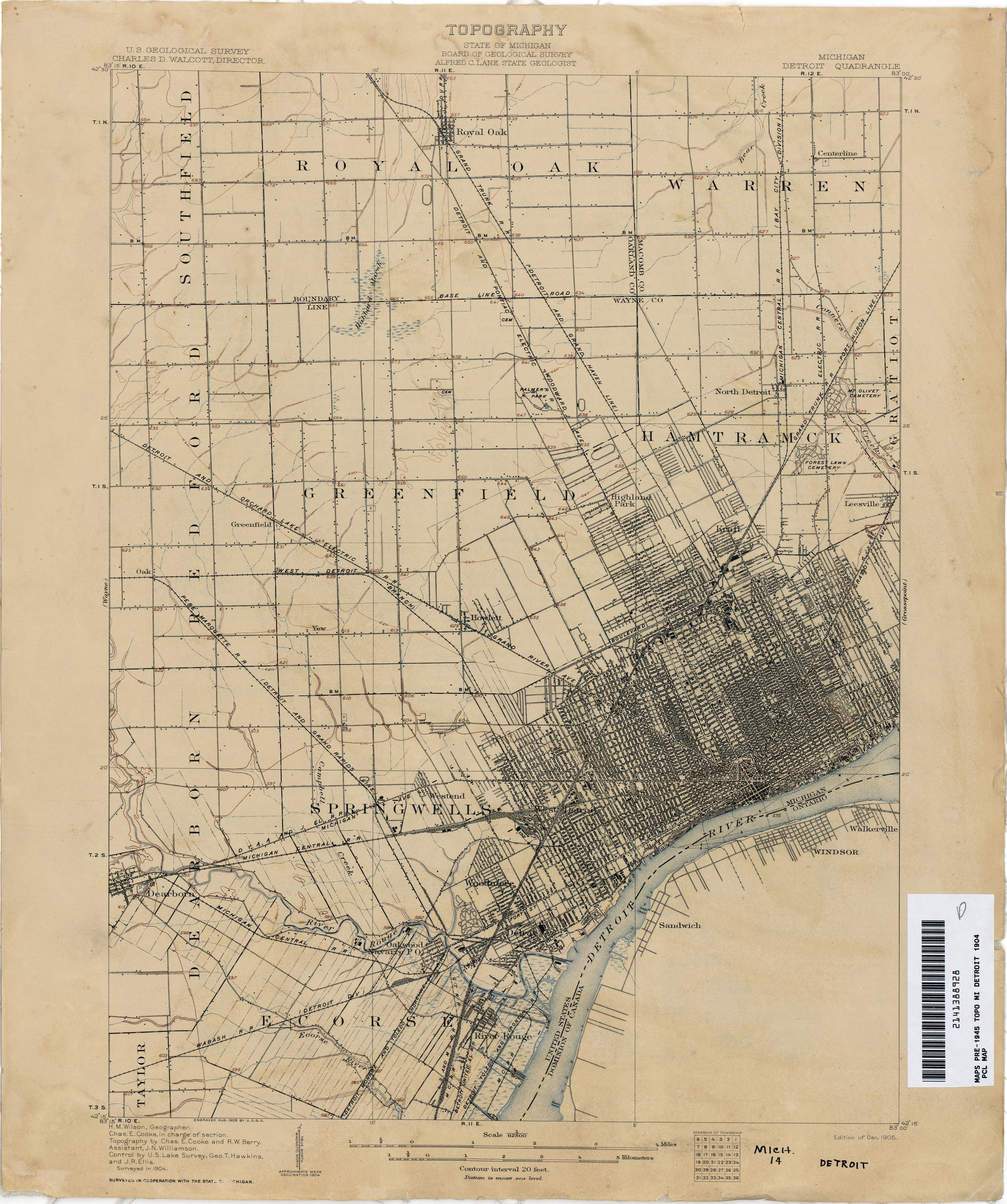
USGS Map of Detroit 1905.
This USGS map of Detroit from 1905 is interesting in that it shows that all the "mass transit" cities are attempting to create now were already well in place at the turn of the last century. If you download a high resolution copy of this map from the University of Texas at the "source" link listed below you will see that mass transit covered Detroit like the main arterials and now the freeways do.
Going in a clockwise direction around the city, in 1905 we had:
- DETROIT TOLEDO AND IRONTON R.R
- DETROIT UNITED ELECTRIC R.R
- DETROIT MONROE AND TOLEDO SHORELINE ELECTRIC R.R.
- WABACH R.R. (DETROIT DIV.)
- MICHIGAN CENTRAL R.R.
- DYAA AND J ELECTRIC R.R.
- PERE MARQUETTE R.R. (DETROIT AND GRAND RAPIDS LINE)
- PERE MARQUETTE R.R. (WEST DETROIT BRANCH)
- DETROIT AND ORCHARD LAKE ELECTRIC R.R.
- DETROIT AND PONTIAC ELECTRIC R.R.
- GRAND TRUNK R.R. (DETROIT AND GRAND HAVEN LINE)
- MICHIGAN CENTRAL R.R. (BAY CITY LINE)
- GRAND TRUNK R.R. (PORT HURON LINE)
And on an associated map covering Grosse Point heading northeast you have:
- DETROIT AND PORT HURON ELECTRIC R.R. (running along Gratiot Ave.)
- DETROIT AND PORT HURON ELECTRIC R.R. (running along Jefferson along the lake)
Fifteen different rail lines heading into the city! I wonder, has our love affair with the automobile really been worth it?
Source: University of Texas at Austin, Perry-Castaneda Library Map Collection, Michigan Historical Topographic Maps (http://www.lib.utexas.edu/maps/topo/michigan/txu-pclmaps-topo-mi-detroit-1904.jpg)
Any copyrighted material incorporated on this site is used in "fair use", for the purpose of study, review or critical analysis only, and will be removed at the request of the copyright holder. Contact Webmaster at jmk@63alfred.com
Copyright © 2004-2010 John Kossik, All Rights Reserved.
Contact | About the Author